
|
|


September 2, 2005
New Orleans, Before
By SCOTT FYBUSH
I never expected to use these pictures here on Tower Site of the Week. Frankly, they're lousy tower images. You see, my one visit to the region, for the NAB Radio Show in September 2001, found lots of rotten weather. If the sky wasn't slate gray behind the towers, and if I wasn't getting drenched by a sudden downpour, then the sun had just come out right behind the sticks - or the site was buried deep in the woods and was inaccessible.
I flew out of New Orleans under pouring rain on a Saturday afternoon in early September, and the memories of that trip were soon inextricably intermingled with the tragedy three days later, much closer to home. I had the intention, especially after some interesting conversations earlier in 2005 with several New Orleans engineers, of going back at some point to get better views of these sites and to spend more time in this remarkable city.
 But
now New Orleans is the scene of an unimaginable tragedy of its
own, and it's hard to say when - or even if - that opportunity
will again present itself.
But
now New Orleans is the scene of an unimaginable tragedy of its
own, and it's hard to say when - or even if - that opportunity
will again present itself.
So these pictures come out of the album and on to the scanner, and we offer you a humble look at what New Orleans radio and TV looked like four years ago this week, back in a happier time.
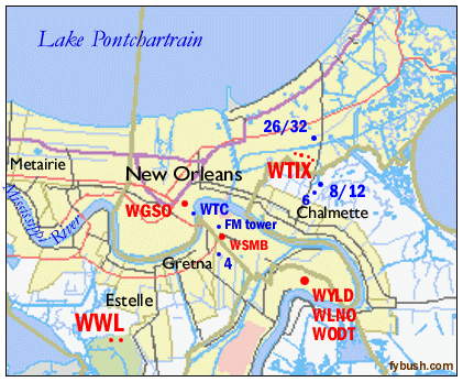
First, the geography. The same factors that made New Orleans so vulnerable this week made it an easy place to put radio stations. AM stations function best in low-lying areas with a salt-water ground, and there's nowhere in the country that offers more of those than the outlying areas of the city. TV stations transmit best when there's no terrain blocking their signals from viewers, and as we learned all too well this week, there's simply no terrain at all to speak of for miles around New Orleans.
Our visit to the region actually began northeast of New Orleans, in the area that would take the most savage pounding from Katrina. That first night, I drove over the I-10 causeway to Slidell (off the upper right corner of this map, it's the roadway you may have seen in dozens of pieces on your TV this week) and out to the Mississippi state line, where I was welcomed with an expensive speeding ticket and a thunder, lightning and rain storm that was one of the worst I'd ever seen, though it was nothing out of the ordinary for the area, apparently. Had it not been for those two factors, I'd have some images of Biloxi radio to put here, too, but instead I had a soggy dinner at a Waffle House and headed back to Slidell for the night.
Over the next couple of days, I was able to squeeze in a few tower trips closer in to New Orleans among the events at the Radio Show, and here are some of the highlights:
 |
|
|
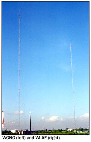
The biggest concentration of towers in the New Orleans area is found east of town, where Louisiana 47 cuts across a series of canals, levees and lakes as it heads south from I-10 into Chalmette. At the northern end of the cluster sit the newest towers: one for Tribune's WB affiliate, WNOL (Channel 38) and its ABC affiliate, WGNO (Channel 26), which moved here from a rooftop site we'll see in a bit, and one for WLAE (Channel 32), the secondary public TV outlet in town. The WLAE tower is (or was, as this entire site is off the air) shared with FM stations WRNO (99.5), WNOE (101.1) and WKBU (105.3 Kenner, which was on a different site in 2001.)
Keep going south, and the four towers of WTIX (690) soon appear out in the water. This was one of Todd Storz' legendary top-40 stations back in the day; today, with 10 kW by day and 5 kW at night, it's a locally-owned news/talk station that's managed to stay on the air through much of Katrina's aftermath with important news and emergency information for the city.
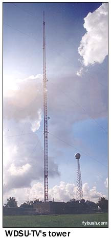
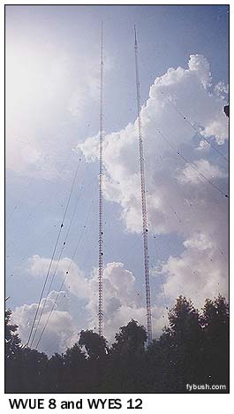
Further south, rising from a field in a residential neighborhood, we come to the sites of Fox affiliate WVUE (Channel 8) and its neighbor, public TV WYES (Channel 12), which swapped channels back around 1970. (Both went off the air at the height of the storm and have not returned.) The southernmost of the Chalmette sites is that of NBC affiliate WDSU (Channel 6), one of two New Orleans stations that's struggled to stay on the air with emergency information. (At last word, this site was off the air, but WDSU's programming continues on the web, fed from an emergency studio at WDSU's sister station WAPT in Jackson, Mississippi.)
As befits a channel 6, WDSU shares its site with two FMs that would otherwise have the potential to cause interference to its signal. WRBH (88.3) is one of the few high-power FMs that does reading for the blind on its main channel, while WBSN (89.1) is Jimmy Swaggart's flagship.

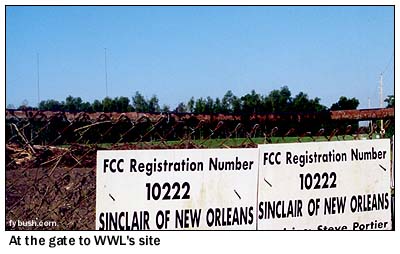
If Chalmette holds the region's crown for sheer number of towers in a concentrated area around New Orleans, the Estelle area, five miles south of New Orleans, can at least boast the most important single site in the region.
 |
|
 WWL
is no doubt the first station that comes to mind when you think
of New Orleans, and with good reason: its 50 kilowatt signal
is one of the old class I-A clears, the elite category of stations
that can operate nondirectionally day and night without protecting
anyone else on the channel.
WWL
is no doubt the first station that comes to mind when you think
of New Orleans, and with good reason: its 50 kilowatt signal
is one of the old class I-A clears, the elite category of stations
that can operate nondirectionally day and night without protecting
anyone else on the channel.
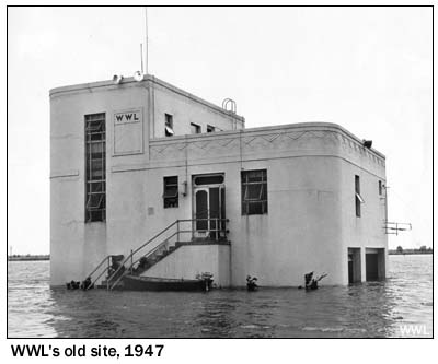
Owned for most of its existence by Loyola University of the South, WWL was for many years located in Kenner, on the south shore of Lake Pontchartrain west of New Orleans, not far from the present-day Louis Armstrong International Airport.
That site suffered floods, too, like the one pictured at right in 1947. Look closely, and you might just be able to make out a soggy engineer drying himself out on the steps near the rowboat.
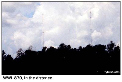
In 1975, WWL left Kenner and moved to its current site in Estelle, which has to be one of the most unusual of any radio station in the country.
The two towers (a configuration chosen at WWL's option, to reduce wastage of signal over the Gulf of Mexico; the station could return to ND operation at any time) and octagonal transmitter building (to minimize windload) were built more than a mile west of Louisiana 45 (Barataria Boulevard), in a wetland that's outside the levee system meant to protect New Orleans from flooding. Without that protection, legendary engineer Oggie Prestholdt put the towers and the building on 12-foot concrete piers and specified huge fuel tanks and a generator. The idea was to create a site that could ride out the worst storm imaginable. It almost worked. The towers and building survived unscathed - but at 12:44 Sunday morning, the generator failed, and it was the better part of a day before engineers could reach the site to restart it, leaving WWL at first silent and then operating at reduced power from an auxiliary site.

 That auxiliary site
was a longwire antenna at the tower of WWL-TV (Channel 4) in
Gretna, just across the Mississippi River from New Orleans' Central
Business District (CBD).
That auxiliary site
was a longwire antenna at the tower of WWL-TV (Channel 4) in
Gretna, just across the Mississippi River from New Orleans' Central
Business District (CBD).
WWL-TV and WWL radio are no longer co-owned; the radio station now belongs to Entercom, and the TV station is part of the A.H. Belo group, with the AM auxiliary antenna at the TV site as the last remnant of the old co-ownership.
Of all New Orleans' TV stations, WWL-TV put up the best fight against the storm. Many of its staffers moved from the station's French Quarter studios, which we'll see in a bit, to Louisiana State University, 70 miles to the west in Baton Rouge, and from there they kept programming coming to this transmitter. Late on Monday, the station set up a temporary studio right in the transmitter building, and it's been carrying on from there and Baton Rouge via the transmitter here and on the web, delivering a remarkable and moving broadcast.
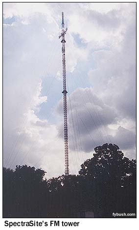
Gretna is also home to what's proved the most usable FM site in the wake of Katrina, the SpectraSite tower a few miles north of WWL-TV that carries public radio WWNO (89.9), Entercom's WTKL (95.7), WEZB (97.1) and WLMG (101.9) and Clear Channel's WQUE (93.3). With the exception of WWNO, which shut down when its staff evacuated on Sunday, the other FMs on the SpectraSite tower have been on and off the air in various configurations ever since. (In a bid to save precious generator fuel, Entercom and Clear Channel are collaborating on a joint broadcast of emergency information, using only one of the transmitters at this site at a time.)
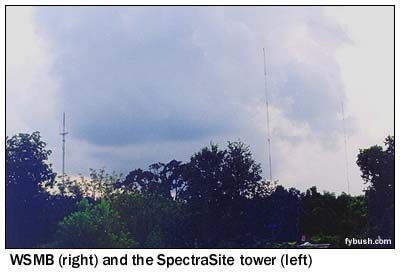 (The
SpectraSite tower also made a cameo appearance on some aerial
video shot by WDSU on Tuesday, surrounded by water but continuing
to function.)
(The
SpectraSite tower also made a cameo appearance on some aerial
video shot by WDSU on Tuesday, surrounded by water but continuing
to function.)
Another Entercom station sits near the SpectraSite tower. WSMB (1350) runs 5000 watts, DA-N, from two towers; it's off the air at the moment so that Entercom can focus resources on WWL, but normally it's programming progressive talk these days. (In 2001, it was a sort of farm-team talker to the big gun of WWL, with a variety of food shows and other programming that was a little far off the beaten path for 870.)
There are three more AM stations east of here, and our pictures are so mediocre that we won't even show them here. Clear Channel's WYLD (940), and WODT (1280, the old WDSU) and Communicom's seven-tower WLNO (1060, the old WNOE) are all near each other down near Belle Chasse, in particularly low land near a bend in the Mississippi. Little is known right now of the fate of these sites, though there was a report that WLNO remained on the air much of Sunday night with paid religious programming and infomercials.
There are a few other AMs in the market that are not depicted here: WVOG 600 and WBYU 1450 are the lone New Orleans AMs west of the city, in Metairie along the north shore of the Mississippi.
 WSHO
800 has a two-tower site not far from WWL and from the former
site of WRNO Worldwide, the once-great station that's been silent
for a few years now.
WSHO
800 has a two-tower site not far from WWL and from the former
site of WRNO Worldwide, the once-great station that's been silent
for a few years now.
KKNO 750 and KGLA 1540 share a nondescript tower in Marrero, due south of New Orleans. And Bishop Willis' WBOK 1230 was operating from a short tower on the city's east side, near I-10, though it had been silent for a while even before Katrina.
 There's
one more AM to be accounted for: WGSO (990) is a rooftop site,
and you can see its tower just to the right of the skyscraper
in the photo above, shot from the edge of the French Quarter
across Rampart Street from the WWL-TV studios.(The other rooftop
tower, atop that skyscraper at the center of the photo, is home
to funky public radio station WWOZ 90.7. It doesn't sound like
the CBD rooftops did very well during the storm, and I wonder
how these towers fared.)
There's
one more AM to be accounted for: WGSO (990) is a rooftop site,
and you can see its tower just to the right of the skyscraper
in the photo above, shot from the edge of the French Quarter
across Rampart Street from the WWL-TV studios.(The other rooftop
tower, atop that skyscraper at the center of the photo, is home
to funky public radio station WWOZ 90.7. It doesn't sound like
the CBD rooftops did very well during the storm, and I wonder
how these towers fared.)
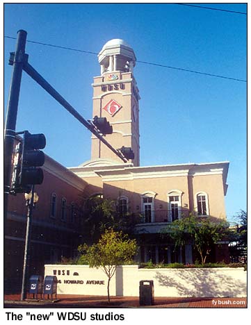
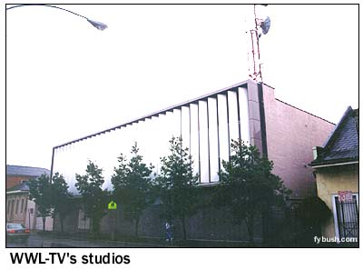
The WWL-TV studios weren't very impressive from the outside - a nondescript concrete box on the edge of the French Quarter, with none of the charm of the old WDSU studios in a 19th century French Quarter building on Royal Street and none of the efficiency of the high-tech "new" WDSU facility on Howard Avenue that was just a couple of years old when I photographed it in 2001. Earlier in 2005, WWL-TV announced plans to move out of this building into a new facility on Canal Street in the CBD; those plans may well be accelerated now, as the old studios on Rampart may not be salvageable when the water recedes.
WVUE's studios are the most likely to survive. They're not pictured here, but they're built well above ground off I-10 at Jefferson Davis Parkway, west of the CBD.
And we mentioned earlier that we'd show you where WGNO used to be. Their old transmitter site is still a licensed aux site, atop the World Trade Center building on the edge of the Mississippi at the foot of Canal Street, and the station's studios are still in the building, which was evacuated well in advance of the storm on Sunday.
|
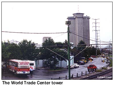 |
That photo of New Orleans' World Trade Center was taken, ironically enough, on September 8, 2001, just minutes before I headed to the airport for the flight back home. It was the last photo I took on this trip, and I can only hope that it won't be the last I take of a New Orleans broadcast site.
 It
will be a while before any of these sites are back to full operation,
perhaps even years. We salute the engineers who are working under
unimaginably bleak conditions to keep radio and TV operating
and informing the people of New Orleans, and we're in awe of
the emergency workers trying to keep peace and save lives and
of the rebuilding task ahead of all of them. Please consider
joining us in making a contribution of any size to the American
Red Cross, to aid in the recovery effort.
It
will be a while before any of these sites are back to full operation,
perhaps even years. We salute the engineers who are working under
unimaginably bleak conditions to keep radio and TV operating
and informing the people of New Orleans, and we're in awe of
the emergency workers trying to keep peace and save lives and
of the rebuilding task ahead of all of them. Please consider
joining us in making a contribution of any size to the American
Red Cross, to aid in the recovery effort.
And with any luck, someday I'll have some new pictures of a rebuilt New Orleans to put in this space.
JUST RELEASED - it's your very first chance to order the 2006 Tower Site Calendar! Click here for ordering information!
- Previous Site of the Week: WJTO, Bath ME
- Next Week: WATD, Marshfield MA
- Site of the Week INDEX!
- How can you help support Site of the Week? Click here!
- Submit your suggestions for a future Site of the Week!