
|
|


November 10, 2006
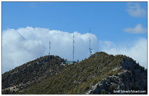
Mount Potosi, Las Vegas, Nevada
 We
thank you for your patience over the last few weeks while we've
been out on the road, enjoying (and catching up from) Big Trip
2006, which you'll see in great detail here on Tower Site of
the Week beginning later this winter.
We
thank you for your patience over the last few weeks while we've
been out on the road, enjoying (and catching up from) Big Trip
2006, which you'll see in great detail here on Tower Site of
the Week beginning later this winter.
This month, we kick off a brand-new season of sites that have never before been seen on Tower Site of the Week - and we'll start with another one of the sites featured in Tower Site Calendar 2007.
This week, it's our April photo - Mount Potosi, 8500 feet above sea level and 25 miles southwest of downtown Las Vegas.
That's airline miles, mind you. Actually getting from the bright lights of the Strip to the towers atop Mount Potosi, in the event you don't have a helicopter at your disposal, is one of the more grueling ordeals in the world of broadcast engineering. (My Radio World colleague Sharon Rae Pettigrew shared some colorful stories from local engineers in an article published just before the NAB show this year.)
 My own
introduction to the experience that is Mount Potosi also came
at NAB 2006, when CBS Radio's Las Vegas chief engineer, Tracy
Teagarden, invited me up the mountain to see his station there,
KXTE (107.5 Pahrump NV). The day before my Potosi trip, I took
part in a group excursion to the other major FM/TV mountaintop
site in Las Vegas, Black Mountain. After bumping and shuddering
up that dirt road, I mentioned to another Vegas engineer that
I was heading to Potosi the next day.
My own
introduction to the experience that is Mount Potosi also came
at NAB 2006, when CBS Radio's Las Vegas chief engineer, Tracy
Teagarden, invited me up the mountain to see his station there,
KXTE (107.5 Pahrump NV). The day before my Potosi trip, I took
part in a group excursion to the other major FM/TV mountaintop
site in Las Vegas, Black Mountain. After bumping and shuddering
up that dirt road, I mentioned to another Vegas engineer that
I was heading to Potosi the next day.
"Potosi?" he asked. "This road's a four-lane paved highway compared to Potosi!"
That, as it happened, may have been an understatement.
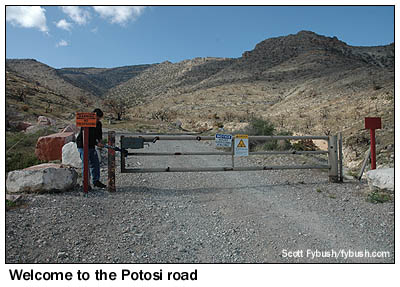
Just getting to the base of the Potosi tower road is a haul from Las Vegas, involving half an hour's drive south on I-15, a turnoff at the Jean/Goodsprings exit, and then a series of gravel roads leading to the gate.
From there, the road's deceptively easy for a little while - until it really starts heading up, by way of a steep climb up a sheer stretch of rock that only the most hardy four-wheel-drive vehicles can manage, and then only in the hands of guys like Tracy who drive the road regularly and know it by heart.
|
|
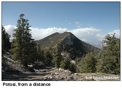
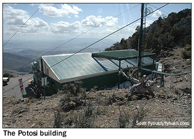
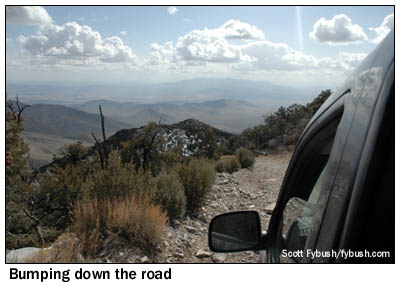
Past that stretch, the road gets marginally easier, but there are still plenty of hairpin turns and sheer dropoffs on the way up to the summit. See that narrow dirt path at the lower left of the photo just above? That's the road - and a pretty decent stretch of it, at that. All told, it takes about an hour, in the experienced hands of a veteran driver, to get to the low-slung green building and the cluster of towers at the summit.
|
|
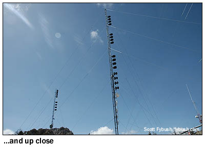
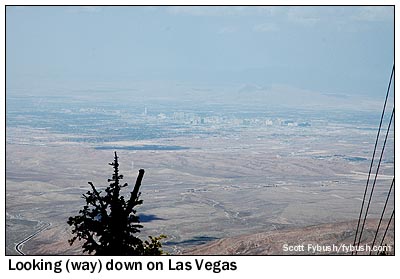
There's a phenomenal view from up at the summit, which goes a long way to explaining what this site is doing out here in the first place. It was developed in the late 80s, when what was then KUDA hit the airwaves on 107.5, licensed to Pahrump, 60 miles from Las Vegas on the other side of the Spring Mountains (the range that runs from Mount Charleston, northwest of Las Vegas, to Mount Potosi). There was only one reasonable spot that could put a city-grade signal over both Pahrump and Las Vegas, and this was it - and so the road was carved into the mountain and the first of these towers went up.
|

|
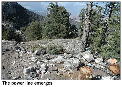
Building the road and the tower and the transmitter building was one thing, but keeping the transmitter supplied with power is an even bigger challenge. There's a fairly conventional power line that runs partway up the mountain, but it stops well short of the summit.
 The
rest of the way, power comes through a single skinny aluminum
conductor that's buried under the road. The photo above at left
shows the power cable lashed to a tree just before it heads under
the road to the summit - and the photo at right shows some of
the array of rotary phase converters that take the incoming power
and convert it to the three-phase supply that the transmitters
need.
The
rest of the way, power comes through a single skinny aluminum
conductor that's buried under the road. The photo above at left
shows the power cable lashed to a tree just before it heads under
the road to the summit - and the photo at right shows some of
the array of rotary phase converters that take the incoming power
and convert it to the three-phase supply that the transmitters
need.
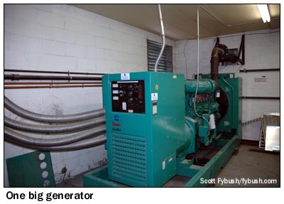
Would you trust your major-market FM signal to that one skinny cable? The engineers up here sure don't - there's a massive, continuous-duty generator sharing the room with the Phasemasters, and it's kept these stations on the air for many months at a time when the "shore power" has been out.
And yes, that's stations, plural. What began with a single station in 1988 has evolved into a site that's home to seven FM stations. The former KUDA on 107.5 is now KXTE, with modern rock. (It boasts the distinction of having been the first FM station to broadcast HD Radio, for a demonstration during the 1999 NAB show, back before the term "HD Radio" had even been coined.)
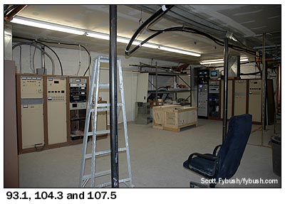
The rest of the Potosi stations are all licensed to Las Vegas, and most of them started out at other mountaintop sites before moving up to Potosi. Clear Channel's rhythmic AC KPLV (93.1) was up here pretty early on, though it was KEYV then, and was still doing oldies as KQOL when we were on the mountaintop in April. In one corner of the building, the 93.1 transmitter sits next to what's now Beasley country station KCYE (104.3), which had just flipped from its longtime identity as standards KJUL. (I'm pretty sure it debuted from Potosi in 1989.)
|
|
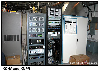
KXTE's transmitters sit in the opposite corner, at right in the photo above. Directly across from the KCYE transmitter are the racks belonging to Nevada Public Radio, which came up here as a single station, KNPR on 89.5, and then found a clever way to split into two services a couple of years ago. The former KNPR license moved from 89.5, where it was a full class C, to 89.7 as a C2. That cleared the way for a new full class C license on 88.9, which took the KNPR calls and NPR news/talk format that had been on 89.5, while 89.7 became all-classical KCNV. (The big Nautel is the 88.9 transmitter; 89.7 runs off that little Nautel exciter and power amps on the left.)
|
|
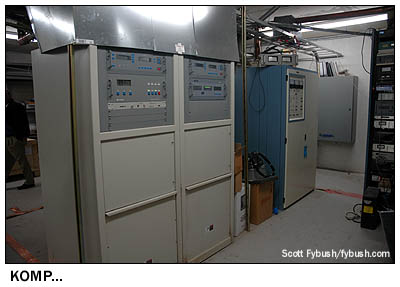
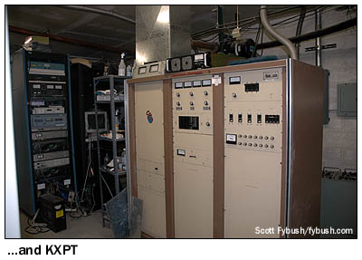
Tucked into a corner next to KXTE are the two Lotus FMs that moved up here from other sites: rocker KOMP (92.3), with the only Harris on Potosi, and classic hits KXPT (97.1), which uses a Continental like the other commercial FMs up here.
 (With
the exception of KCNV and its mighty 550-watt ERP, all the FMs
up here enjoy nearly identical Class C technical facilities,
roughly 25 kW at 3700' AAT. That kind of height gives these stations
remarkable coverage reach, making them audible for close to 200
miles along I-15 from Arizona almost to Barstow, California.
The tradeoff is somewhat less raw signal strength and some multipath
issues in Las Vegas itself, an issue KXPT addresses with a translator
on closer-in Black Mountain. In any case, KXPT and KNPR are our
usual presets for the first part of the long drive from Vegas
to LA.)
(With
the exception of KCNV and its mighty 550-watt ERP, all the FMs
up here enjoy nearly identical Class C technical facilities,
roughly 25 kW at 3700' AAT. That kind of height gives these stations
remarkable coverage reach, making them audible for close to 200
miles along I-15 from Arizona almost to Barstow, California.
The tradeoff is somewhat less raw signal strength and some multipath
issues in Las Vegas itself, an issue KXPT addresses with a translator
on closer-in Black Mountain. In any case, KXPT and KNPR are our
usual presets for the first part of the long drive from Vegas
to LA.)
One more bit of Mount Potosi trivia, which I didn't even learn until long after my visit to the mountaintop: while researching this week's Site of the Week, I found out that the mountain is also known as the site of the 1942 plane crash that killed actress Carole Lombard. The wreckage of the DC-3 is apparently still visible not far from the towers.
(And Lombard, we should add, is one of the most famous natives of Fort Wayne, Indiana, a community that should be familiar to Site of the Week readers as the home of the in-laws and starting point for our frequent midwestern excursions.)
 From the summit,
it's a long, bumpy ride back down the road to the gate, and then
another hour or so back to Las Vegas, which seems even louder
and more garish than usual after our excursion to this most remote
of transmitter sites.
From the summit,
it's a long, bumpy ride back down the road to the gate, and then
another hour or so back to Las Vegas, which seems even louder
and more garish than usual after our excursion to this most remote
of transmitter sites.
The Tower Site Calendar 2007 is here! It's not just Mount Potosi - but a dozen more great photos of transmitter sites near and far. Be one of the first to receive your copy - order today at the Fybush.com Store!
- Previous Site of the Week: WGRB, Chicago
- Next Week: Black Mountain, Las Vegas, NV
- Site of the Week INDEX!
- How can you help support Site of the Week? Click here!
- Submit your suggestions for a future Site of the Week!