
Radio-Locator vs. Reality: A Brief(-ish) Explanation
By SCOTT FYBUSH
If there’s one question that I seem to find myself addressing on message boards and Facebook threads more than any other, it’s this one:
What’s up with those coverage maps online?
For better or worse, the dominant source of those maps these days is Radio-Locator.com (“R-L” henceforth), and while R-L offers its own FAQ for its maps, it’s neither especially obvious nor especially comprehensive. So here, I hope, is a somewhat better explanation of how their AM maps intersect with reality.
First things first: there are three concepts at play here, and you need to understand all three to make sense of what’s going on. There is an AM station’s transmitted pattern – the way in which its antenna system sends out differing amounts of signal in different directions. For a non-directional station (for our purposes, that’s generally a station with a single vertical tower radiating its signal), that transmitted pattern is at least theoretically a perfect circle. For a directional station (one, generally speaking, that uses multiple towers), the transmitted pattern can take on all sorts of shapes; in general, the more towers, the more complex the pattern. As that signal goes out along the ground, it’s affected by ground conductivity, which is exactly what it sounds like: the extent to which that groundwave signal is attenuated by the differing characteristics of different kinds of soil and water. Rich, loamy soil (think Iowa or the Dakotas) has high ground conductivity that makes signals carry better. Rocky areas (think New England, or the iron shield of northern Michigan) have poor ground conductivity that doesn’t carry signals as well. Salt water is a fantastic conductor, fresh water less so. The combination of transmitted pattern against ground conductivity is a station’s groundwave coverage.
Which brings us around to maps, and the confusion they can generate. The maps R-L displays are intended to be depictions of groundwave coverage, and as such they often don’t look much like a station’s transmitted pattern. Let’s look at a few examples:

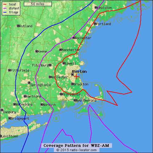 Both the map on the right (from R-L) and the one on the left (from FCCInfo.com) show the same station, believe it or not. (You can click any image on the page to enlarge it.) This is WBZ (1030) in Boston, a 50,000-watt station that transmits with the same directional pattern day and night.
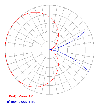
The map on the left is a map of WBZ’s transmitted pattern: its two towers on the coast in Hull, Massachusetts send out their signal day and night in a simple pattern called a “cardioid”: to the west (at 270 degrees), it’s at full power; to the east (90 degrees), it’s at close to zero power, and that’s about it.
All else being equal, then, you’d have maximum WBZ signal to the west and almost none to the east. But of course not all else is equal where New England’s rocky soil meets that sweet, sweet saltwater. On the FCC’s conductivity map, saltwater is a “5000,” while the soil of New England is roughly a “1.” And so when R-L plots the pattern against the conductivity, what comes out is the map on the right: over most of the land area around Boston, both the ground conductivity and the transmitted pattern are roughly constant, and so that red contour line closely traces the I-495 outer beltway in a fairly neat circle around Boston. But to the east, even the relatively minimal signal that comes out of the WBZ towers on that side of the pattern still carries – and carries, and carries – over the highly conductive water, even up along the coast into Maine.
 It’s very common to see people saying of stations in coastal areas that they “send all their signal out to sea,” but that’s not exactly true, no matter how things may appear on R-L’s coverage maps.
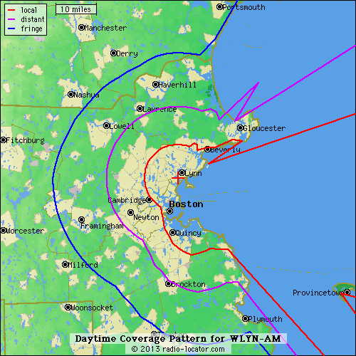
At left, that’s the daytime coverage map of WLYN (1360 Lynn), which is a 700-watt signal transmitting non-directionally from a site just inland on the North Shore, a dozen miles or so north of Boston. Non-directionally? Yes, indeed – and we don’t even have a map of WLYN’s transmitted pattern to show you, because it would be a perfect circle and so FCCInfo and the FCC’s own site don’t bother showing it.
But while that signal goes out just the same in all directions from WLYN’s tower, it doesn’t experience the same conductivity in all directions. Inland from WLYN’s tower, the signal is pretty close to a perfect circle from Beverly around to Cambridge. But look what happens when it hits the water: there’s a spur of signal that carries along the North Shore up past Beverly, then a notch where the Marblehead peninsula blocks the signal from getting to the water, then a giant lobe where the signal hits unimpeded ocean water to the east, plus another spur of signal that carries down the coast along the edge of Boston and down to the South Shore. Does WLYN “send all its signal out to sea”? Not at all – it’s just close enough to the water that the signal goes out to sea whether it’s directed that way or not!
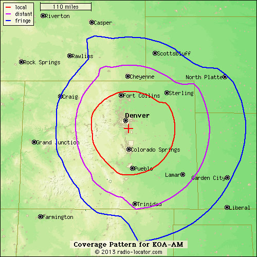
It’s not just water that can affect what happens to a “non-directional” signal. At right above is R-L’s map of KOA (850) in Denver, which is a non-directional 50,000-watt signal that goes out just the same in all directions from one big tower in Parker, Colorado, just south of Denver. But wait – that’s not a circle, is it? To the west, KOA’s signal hits the Rocky Mountains, which, being rocky, don’t conduct AM signals very well at all. To the east, by contrast, that rich soil that extends out to Kansas and Nebraska carries KOA quite well indeed.
Next: Red, Purple, Blue – Understanding What The Lines Mean (coming soon!)
LAST CHANCE TO BUY CALENDARS
The 2026 Tower Site Calendar was the final edition, and there will no longer be a Fybush Media Store.
We still have some old calendars and some books, so if you’ve been planning to buy some but just haven’t gotten around to it — this week is your last chance.
Go to our store now and get your favorite tower pin-ups!
Not sure what pictures are in which calendars? Ask Lisa — she’ll tell you.
Looking to get into station ownership? Our StationSale division has some great new listings for you, including a very successful multimedia combo including radio/digital/print in one of the finest small markets in the region, a major market FM translator opportunity, a profitable Midwest FM, an inexpensive entry into a fast-growing Western market, and a turnkey profitable FM/AM/translator small-market combo that’s ready for a new owner. Drop me a line at scott@fybush.com and I’ll set you up with an NDA and all the details…
And if your noncommercial FM station is ready to think about translators, there’s a filing window coming this fall from the FCC and it’s the perfect time to start making plans.